
GREENSBORO, NC -- The tornado watch has been canceled for our area. The severe weather threat is over as those storms moved to the east.
Timeline As Storms Move Through The Piedmont Triad
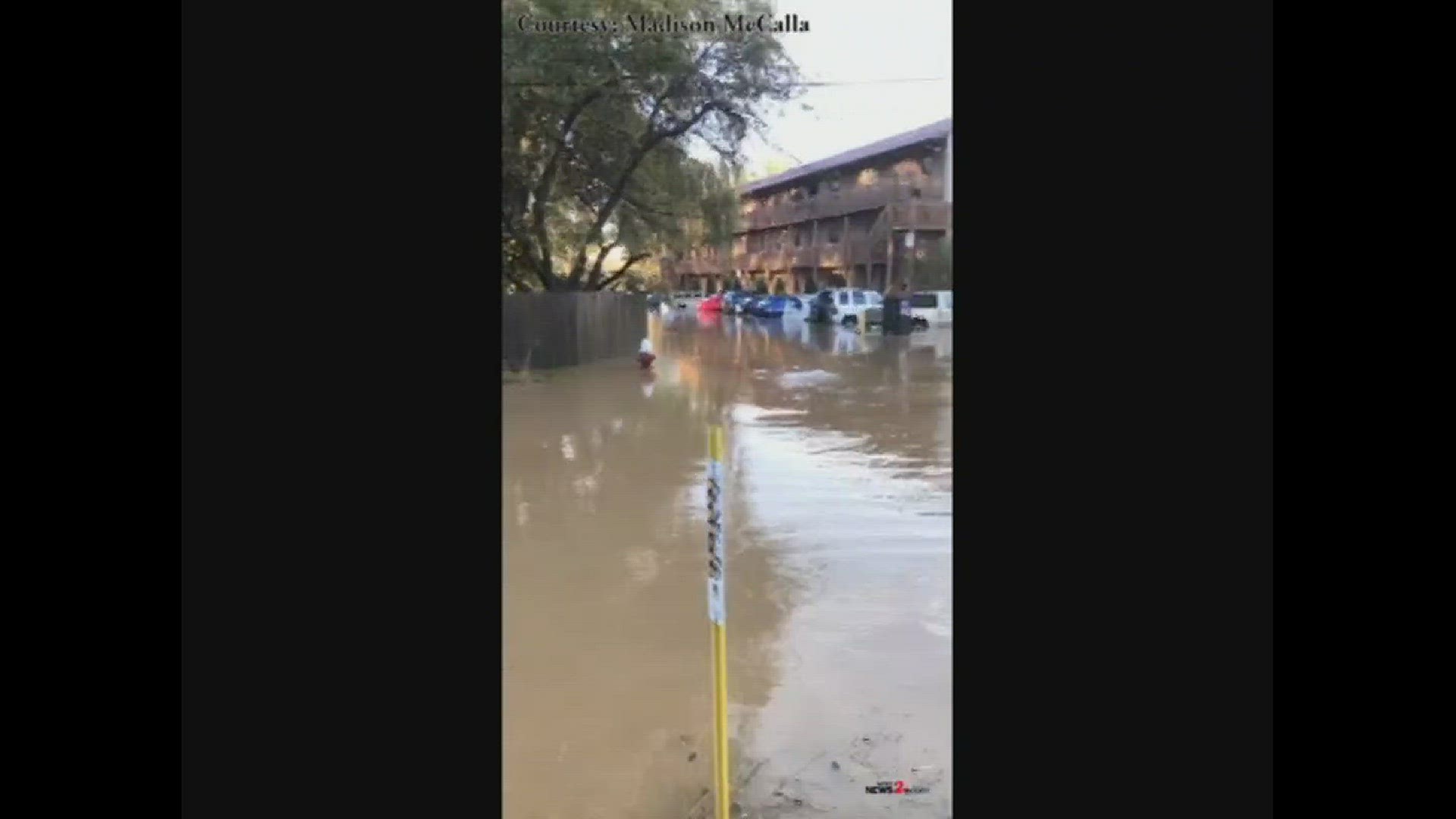
11:00 p.m. - More storm damage from Wilkes County

10:53 p.m. - Nearly 21,000 homes and businesses without power in Wilkes County
10:45 p.m. - Bus takes those impacted by storms in downtown N. Wilkesboro to an emergency shelter as their facility is without power.

10:30 p.m. - People in Forsyth County also saw heavy rain and strong wind. Pfafftown reported trees down in certain areas.
Kristen Daukas said the combination of heavy rain and wind, and the already saturated ground brought down a pine tree close to her house. She said a huge tree also fell on her house when she was younger. She said, “Again you hear that snap and you know it's happening and you have about a millisecond to respond and to react to that and you really can't react you just have to hope for the best that you're not standing where it's going to come down if it hits your house.”
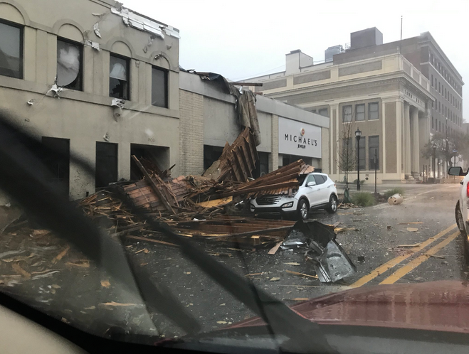
10:09 p.m. - The worst damage in downtown N. Wilkesboro
The worst damage in downtown N. Wilkesboro. Firefighters say most of county is w/o power. The roof is from a building across street. @WFMY pic.twitter.com/r0q3Cgn49l
— Chad Silber (@ChadSilber) October 24, 2017
10:00 p.m. - Tree goes right through house in Gaston County
9:45 p.m. - List of school closings and delays for Tuesday due to the severe weather

9:30 p.m. - Wilkes County Schools closed on Tuesday
9:15 p.m. - Severe weather threat over for the Triad
Just to be clear, the severe threat is over in the Triad. (Continues farther east) #ncwx pic.twitter.com/K4LleCAzqv
— Tim Buckley (@TimBuckleyWX) October 24, 2017
9:10 p.m. - There was also damage in Hickory especially at the airport where the strong wind moved a car right on top of another car.
9:00 p.m. - In Greensboro, a fallen tree took down a power line on West Friendly Avenue near Lindley Road.
Crews worked hard to clear the tree out of the road... and it's now back open.
8:54 p.m. - Over 5 inches of rain today in Boone that resulted in flooding.
WOW! Over 5 inches of rain in Boone today. pic.twitter.com/3mTxTFSQMr
— Tim Buckley (@TimBuckleyWX) October 24, 2017
8:45 p.m. - Some rotation developing in Alamance Co. near Green Level
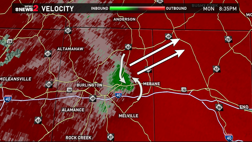
8:35 p.m. - Tracking Storms with Tim Buckley here's another live update
7:53 p.m. - More flooding video from Boone. This is an area that's behind the Walmart Store in Boone.
7:45 p.m. - Tornado warning expires for Rockingham and Caswell counties
7:33 p.m. - Rotation spotted on Radar in Wentworth near Highways 87 & Highway 14
7:32 p.m. - Very heavy rain could lead to flooding.
7:29 p.m. - South of Eden near Wentworth area of concern.
7:25 p.m. - Tornado warning in effect in Rockingham, Caswell, Henry and Pittsylvania Counties; Danville and Martinsville, VA cities until 7:45pm
7:20 p.m. - Tornado warning issued for Rockingham and Caswell counties until 7:45 p.m.
7:10 p.m. - Tornado threat for the foothills is over.
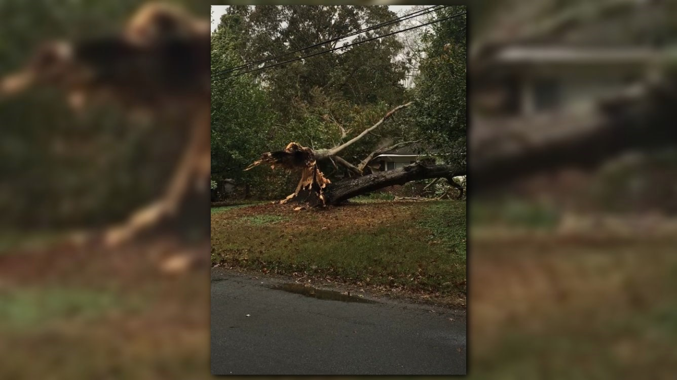
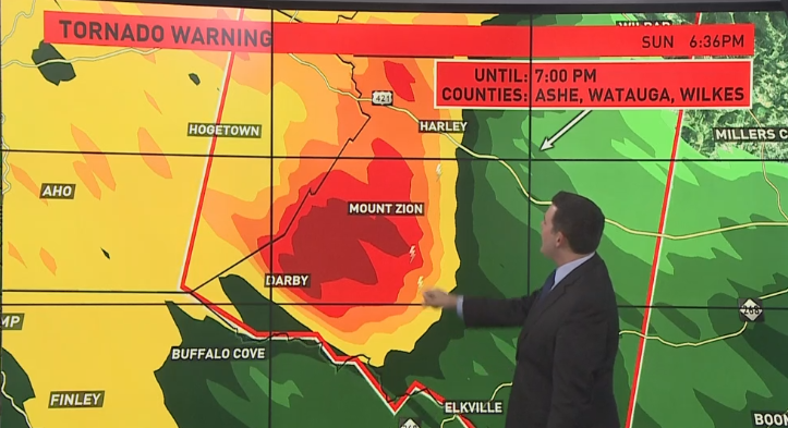
6:36 p.m. - More storm damage reports and photos coming in from Wilkesboro. This picture is from James Farmer of the damage.
@WFMY storm damage in North Wilkesboro, NC pic.twitter.com/fFxjPiHDHO
— James B Farmer (@Jbfarmer10) October 23, 2017
6:10 p.m. - Triad under a tornado watch until 6:00 p.m.
6:06 p.m. - Three barns damaged in Alleghany Co. due to strong winds. One damaged along Glade Valley Road.
6:04 p.m. - 17,000 now without power in Wilkes County
6:03 p.m. - Possible microbursts in Forsyth County
6:01 p.m. - A severe thunderstorm warning is in effect for Davidson and Forsyth Counties until 6:15 p.m.
5:59 p.m. - 5,600 without power in Wilkes County.
5:56 p.m. No longer a tornado threat in Wilkes County and also Alleghany County
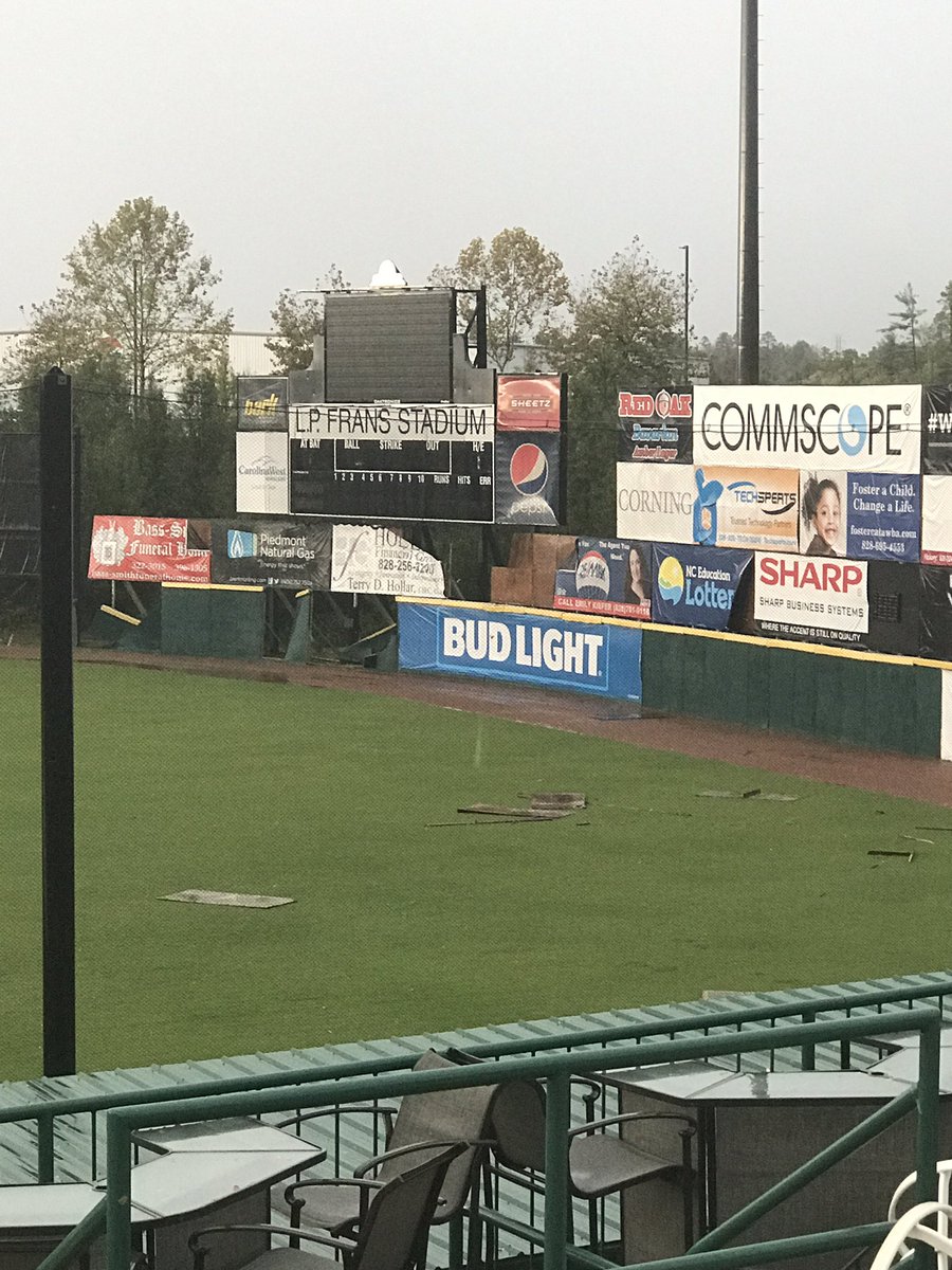
5:55 p.m. - Hickory Crawdads tweets pictures of storm damage to its stadium.
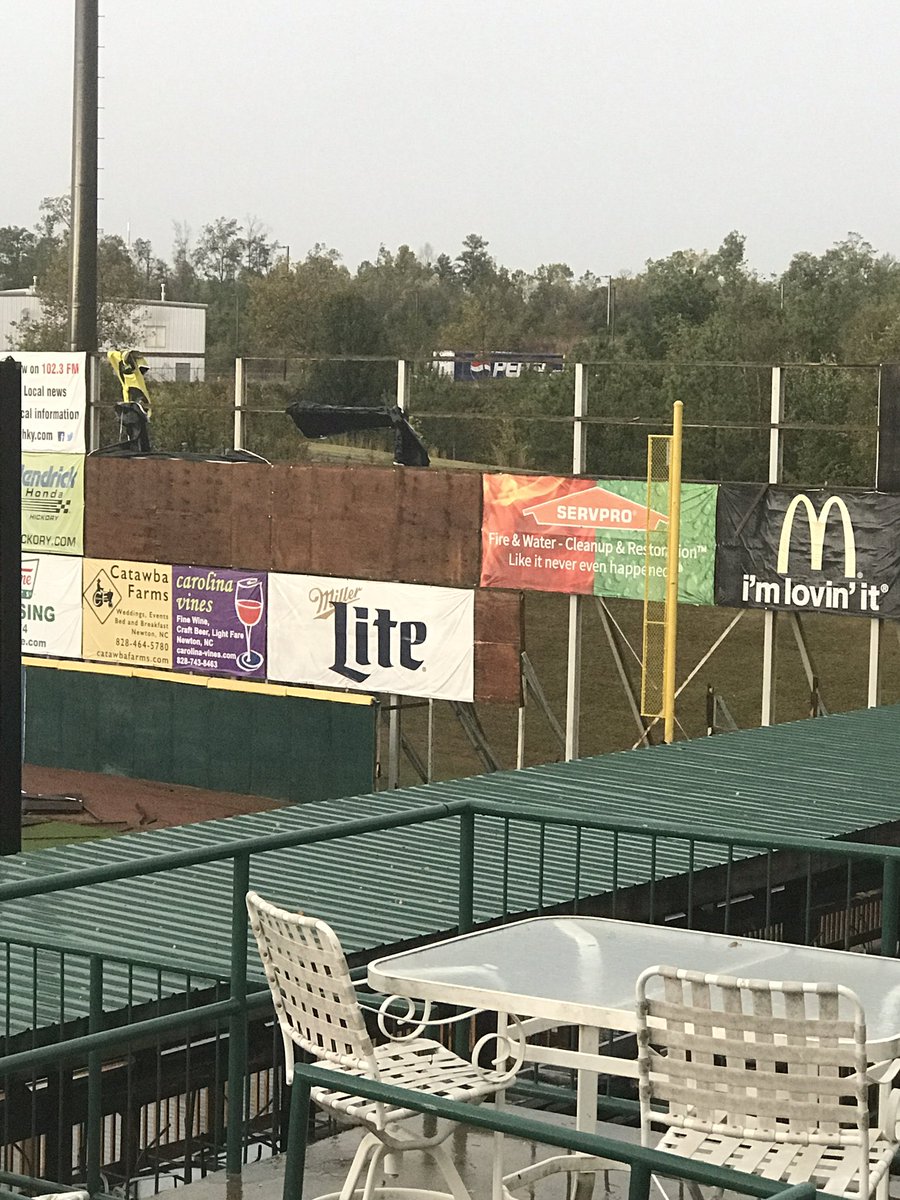
Hope everyone in Hickory and surrounding cities is safe! A tornado recently touched down and did a good but of damage to the stadium! pic.twitter.com/ZAcSpfoaHQ
— Hickory Crawdads (@HickoryCrawdads) October 23, 2017
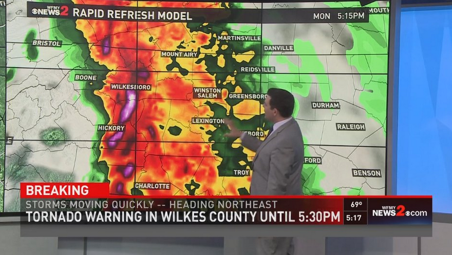
5:53 p.m. - Storms moving quickly headed northeast
5:52 p.m. - We could see more down trees, power lines with this storm system as it moves across the area.
5:48 p.m. - A portion of Surry County also under a tornado warning.
5:46 p.m. - Mocksville getting hit hard now as the storm moves toward Winston-Salem
5:45 p.m. - Strong thunderstorms getting closer to Winston-Salem in the next 15-20 mins.
5:42 p.m. - Two large trees and a power pole down along Little Mountain Church Road in Wilkes. Another tree down along Old Highway 60.
5:40 p.m. - Storms capable of producing 60 mph winds
5:36 p.m. - Photos of storm damage starting to come into the WFMY News 2 Information Center. Email your pictures to myphotos@wfmy.com
5:34 p.m. - Report of a mudslide along NC 321 near the communities of Tweetsie & Mystery Hill
5:30 p.m. - New tornado warning issued for Wilkes, Alleghany, Ashe, & Grayson counties until 6:00 p.m.
5:25 p.m. - Reports of storm damage to a house in Wilkesboro. Also reports of trees down.
5:20 p.m. - Halls Mills & McGrady are towns in the path fo the storm
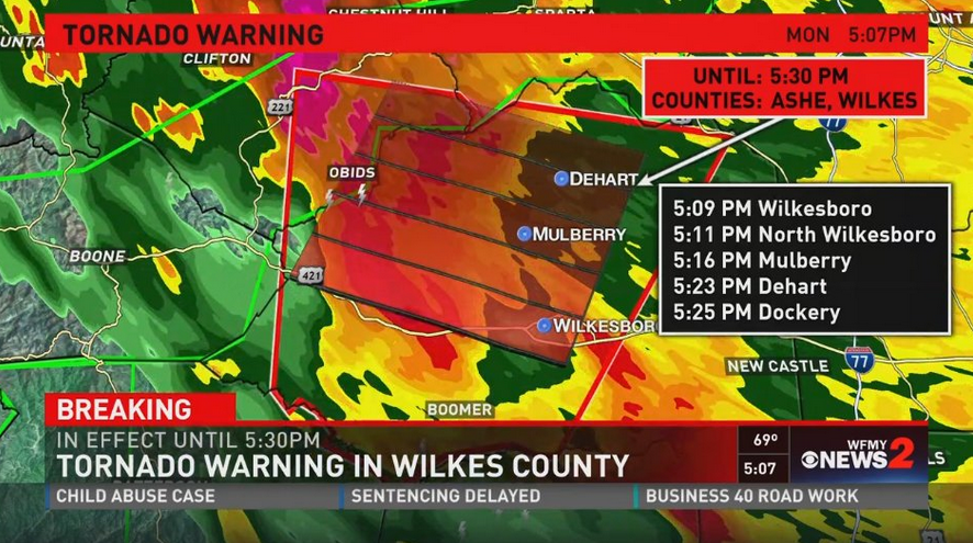
5:18 p.m. - Today marks the second tornado warning in two weeks for Wilkes Co.
5:12 p.m. - Here's a projected path of the storm hitting Wilkes Co.
5:11 p.m. - Moravian Falls, Millers Creek, and Mulberry communities are getting hit hard.
Moravian Falls, Millers Creek and Mulberry communities are getting hit hard. Watch our LIVE coverage here: https://t.co/54tAOt6RWz pic.twitter.com/oDI7Hrp1Zg
— WFMY News 2 (@WFMY) October 23, 2017
5:10 p.m. - Get to the lowest floor possible, Go to an area with as many walls between you as possible. Make sure you stay away from windows.
5:08 p.m. - This storm has brought lots of flooding to Boone.
5:06 p.m. - Reports of trees down in some areas in Wilkes County.
5:05 p.m. - A Tornado Warning has been issued for Wilkes County until 5:30 p.m.
TORNADO WARNING
A tornado warning means a tornado has been reported by spotters or indicated by radar and there is a serious threat to life and property to those in the path of the tornado.
TORNADO SAFETY TIPS
From the National Weather Service
The safest place to be is an underground shelter, basement, or safe room.
If no underground shelter or safe room is available, a small, windowless interior room or hallway on the lowest level of a sturdy building is the safest alternative.
Mobile homes are not safe during tornadoes. Abandon mobile homes and go to the nearest sturdy building or shelter immediately.
If you are caught outdoors, seek shelter in a basement, shelter or sturdy building. If you cannot quickly walk to a shelter: Immediately get into a vehicle, buckle your seat belt and try to drive to the closest sturdy shelter.
If flying debris occurs while you are driving, pull over and park. Now you have the following options as a last resort:
Stay in your vehicle with the seatbelt on. Put your head down below the windows, covering with your hands and a blanket if possible.
If you can safely get noticeably lower than the level of the roadway, exit your car, and lie in that area, covering your head with your hands.
Your choice should be driven by your specific circumstances
House/Stand-alone building:
Get to the lowest level possible
Go to an area with as many walls between you as possible
Get in a bathtub or interior closet
Mobile Home:
Get out of the mobile home and get in a sturdy building if possible
Get out of the mobile home and hunker in a ditch
If no ditch or building is nearby, plan ahead and get to a sturdy building ahead of time
Apartment:
Get to the lowest level (go to a neighbor's apartment on the first floor)
Regardless of what floor you're on, get in a bathtub or interior closet
If you are on a higher level and can't get to a lower apartment, hunker down in the breezeway of the apartment building
Car:
If possible, pull over, park, get inside a building and out of the storm
If you have to stay in your car, try to find a ditch to park in and use your emergency break
DO NOT park under a bridge or overpass
Miscellaneous Tips for Keeping Safe in a Tornado:
Cover yourself with a mattress, sleeping bags, or pillows
Wear a helmet to protect your head
Hunker down as much as possible

TORNADO WATCH DETAILS
A Tornado Watch is in effect for our area until 9pm. That means severe weather is possible, including the threat for tornadoes. Make sure you're staying weather aware.
The WFMY News 2 Weather Team is tracking a cold front moving eastward into the Carolinas today. It's a strong front, and has high winds just above the surface today. Any of these high winds could be brought down to the surface from any thunderstorms that area able to form.
► Make it easy to keep up to date with more stories like this. Download the WFMY News 2 App now
The main threats we'll be tracking will be the opportunity for gusty, damaging winds this afternoon and evening. However, there is some potential for rotating thunderstorms, which can mean a few tornadoes could happen across the state as well, including in the Piedmont. Localized flooding in heavy rain bands can't be ruled out either.
► Make it easy to keep up to date with more stories like this. Download the WFMY News 2 App now
Keep it with the WFMY News 2 Weather Team for updates.