
GREENSBORO, N.C. — Ready or not, here it comes. Winter 2023-24 is right around the corner and many North Carolinians want to know if we're getting snow. The WFMY News 2 Weather Team has been hard at work analyzing the current weather pattern, digging through past data, and looking at climate trends to put together the most accurate Winter Forecast for the Piedmont. The news may be promising for snow lovers!
We've been in a snow drought
It's no secret that snow has been hard to come by in recent years. This past winter was the first in 30 years to feature no measurable snow in our area. The last time that happened was 1991-1992. The last time measurable snow fell in our area was nearly two years ago in January of 2022.
The last time we picked up more than 2" of snow was back on Jan. 16, 2022, when we got 3.3" of a snow/sleet mixture. That's the last time our area was truly shut down by a winter storm. Schools closed for a week.
To find the last "big one" you need to dig back almost five years from now to 2018. On Dec. 9 and Dec. 10, 2018, we got walloped with a huge snowstorm. 12.8" of snow fell and didn't mix with ice at all. It was the last time our area had seen 4" or more of snow.

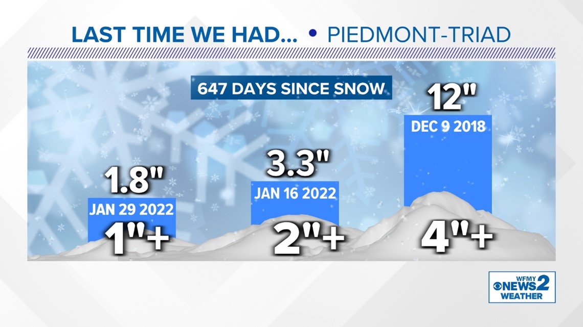
On average, the Piedmont-Triad sees about 7-8" of snow in a typical winter. Last year we picked up only a trace.
The main cause for the lack of winter weather was a back-to-back-to-back La Nina weather pattern, which makes storms less frequent. That's gone now - so could it change?
"Strongest El Nino in Years"
One important factor in winter weather forecasting is a climate trend called ENSO - or the El Niño-Southern Oscillation. This is a fancy way of saying we care about the temperature of the water in the Pacific Ocean near the equator.
When water temperatures in the Pacific Ocean near the equator are warmer than usual, we call that an El Nino pattern. When they're cooler than average, it's called a La Nina. Believe it or not, it has played a big role in the global climate for several months.
The past few winters we have been in a La Nina pattern. This year, that's all changed. Right now, we're seeing the strongest El Nino in years developing just before we enter the winter season.
What does that do? Well, it strengthens the subtropical jet stream across the southern United States. This means there's an easier way to transport moisture from the Pacific Ocean across the southern United States and it usually brings us more frequent storms.
At the same time, during an El Nino winter, the bitterly cold Arctic air in Canada can stay more "cooped up" than usual and not travel south as often.
To sum it up, we have a strong El Nino for the first time in several years. This usually means more storms for us during the winter months. While this may sound like a lot more snow, with less Arctic air, it doesn't always work out.
Winter Warming in Recent Decades
It's important to consider climate trends when looking at a long-range forecast. You've probably noticed it doesn't get quite as cold as it used to around our area during the winter months. Well, the data backs that up.
We have a few ways to show this. One, we can look at the average winter temperature over the last few decades. This includes highs and lows combined. Over the last 50 years, there's been warming of over 4 degrees during our winter months. That might not sound like much, but it is significant to the type of weather we receive.
We can also look at how often it gets cold. Take for example the number of nighttime lows we have below freezing each year. Over that same 50-year period there's been a sharp decline in freezing nights here in the Piedmont.
Given a warmer overall winter climate, it can be more difficult to achieve winter storms even with a favorable El Nino pattern.
What Does the Data Say?
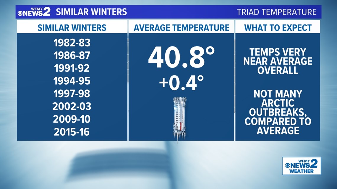
Our team picked out winters that had a similar strong El Nino signature in the last 50 years. From these winters, we can draw some conclusions about our chances of being warm or cold, wet or dry, snowy or not. This isn't a perfect method, but the past can help predict the future.
Looking at this years with similar conditions there was not much of a temperature signal. The average temperature was 40.8 degrees during these years. Just about a half a degree above average.
With precipitation, there was a stronger signal. The average precipitation during these winters was nearly 11", which is above a full 1.6" above our winter average. This gives some confidence that strong El Nino years do produce wetter winters more often than not.
With snowfall, there was a trend! On average, we picked up about 9" of snow in these winters. That's above average for our area by an inch or two. Of these 8 winters, 3 were well above average with some big totals, 2 were duds with little snow, and the remaining 3 were near average.


So What's the Forecast?
After analyzing the current weather pattern, looking at past years, and considering recent climate trends, it's time to boil it down to a forecast. The strongest signal this winter is for it to be a bit wetter than usual. There is also a good chance it will be our first winter in a few years with some decent snow for a change. Temperatures are likely to be close to average, with limited outbreaks of Arctic air.
- Above-average rainfall is likely over the next few months
- This could help our growing drought concerns
- Temperatures are likely to be near average, with limited cold air outbreaks due to El Nino and climate trends
- More snow chances than in recent years, with a good chance to be near our average amount (7-8")

