
GREENSBORO, N.C. — After a dry and chilly week, our weather is about to busy again by the end of the weekend. A strong storm system is developing in the Gulf of Mexico and is headed our way Sunday. It's forecast to become a strong Nor'Easter as it moves north along the east coast, bringing tons of rain and strong wind to parts of the Carolinas and eventually up into parts of New England by the middle of next week.
Over the last couple of days the track of the storm has become much clearer, likely taking a path along the coast, bringing the highest impacts of rain, wind, and flooding at the beaches.


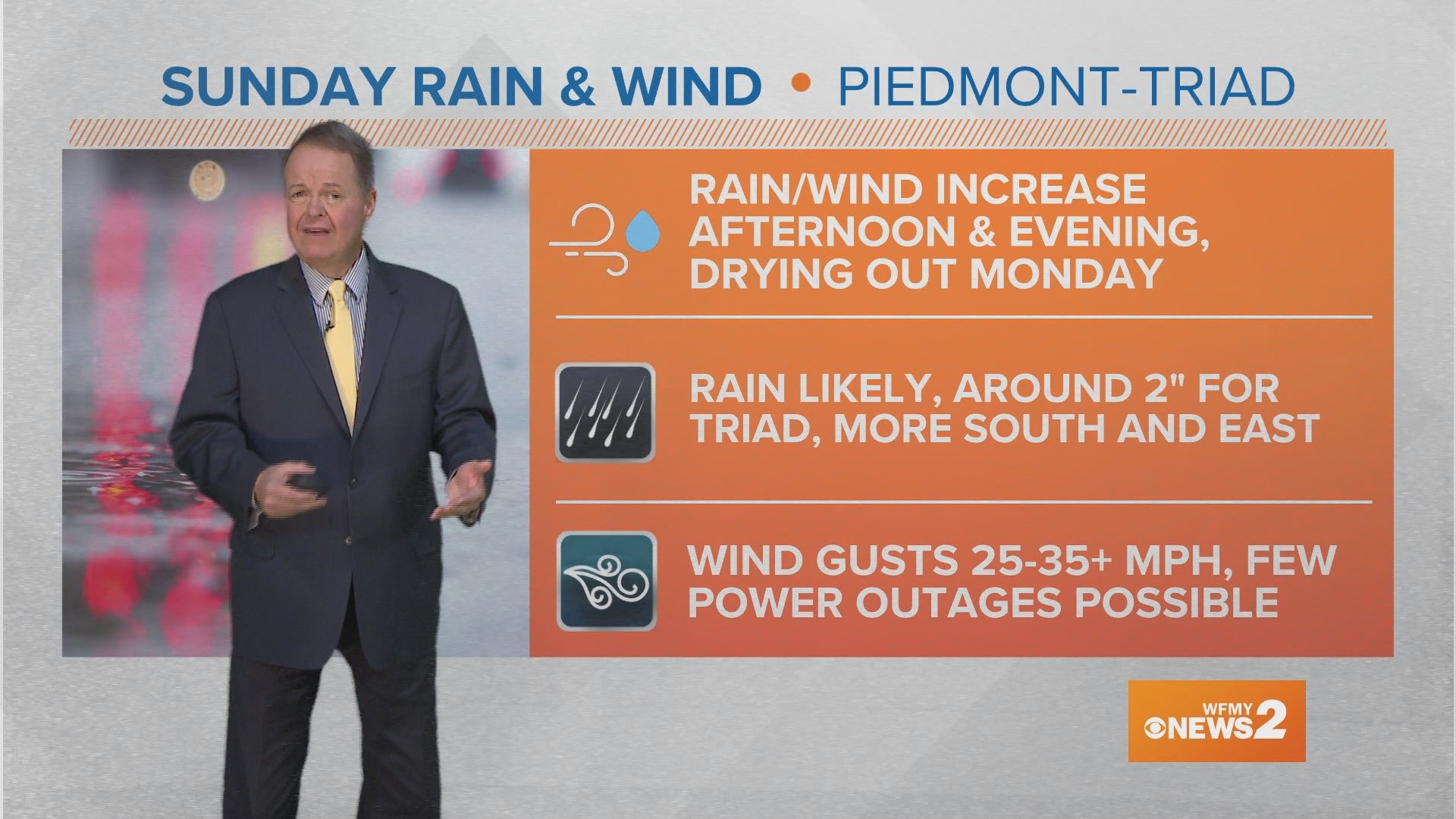
What To Expect Sunday:
A light, but steady rain is moving into the Piedmont from the south. Pockets of heavy rain, along with gusty winds will arrive this afternoon and evening. Rain will taper off after midnight and heading into Monday, but it will still be windy through Monday, and even still breezy Tuesday.
Rain will be likely all day but wind likely won't pick up until the evening as the center of the low passes east of the Piedmont Sunday evening. Our system has trended a bit more back to the east and along the coast, meaning the heaviest rain could fall to our east along with the highest winds, too.
Sunday will be a chilly day likely with highs only in the upper 40s with the chilly rain
How Much Rain Will We Get?
This is shaping up to be a widespread rain event with some pretty hefty totals possible for our area. At this point, on Friday morning, we should plan on at least 1"+ with even higher totals around 1-2" for most of our area, with even higher totals near 3" to our south and east.
The current track of the system has trended a bit more back to the east, meaning a more coastal track. This would bring the highest rain totals to eastern North Carolina and along the beaches, with some folks nearing the 4" mark for rain. Flooding will be a big issues at the beaches along with high tide, too. Much less rain is expected in the mountains.


After over 3" last weekend, this could be more beneficial rain to help improve our drought, but it also could cause some flooding concerns. Most of North Carolina is in a level 2 risk for flooding on Sunday, with the typical trouble spots seeing issues first.
How High Will the Wind Be?
This will be a strong area of low pressure moving north and an area of high pressure to our north, those big pressure differences will help create a big wind field and possible high winds for our area too.
Wind gusts in the 25-35 mph range are likely as a general rule, but potentially could be higher if the track of the storm wiggles a little further to the west. Still though, higher gusts are expected along the coast.


A few wind gusts of this magnitude wouldn't really be much of a problem, but with wet soil already from last weekend's rain, along with gusty winds for a while may cause a few trees to topple and some isolated power outages, but it's not expected to be a widespread problem.
Down at the OBX this will be a very problematic weather system causing lots of flooding issues. This will likely close the famous HWY 12.


Will There Be A Severe Weather Threat?
This time around, there likely won't be a severe weather threat in our area as our "fuel" for storms will be very limited to folks along the coast. Winds will be whipping at the ground and in the upper atmosphere, so the coast may still need to keep a close eye on things to see if some of that potential "fuel" could be realized. For now, severe weather isn't likely for the Piedmont.


What Should I Do?
It's a good idea to make sure that your gutters are clean from leaves piling up, which can happen this time of the year. Also, by Saturday night, all Christmas and Holiday decorations in the yards should be tied down or brought in.


Bottom line, we're in for another soaking wet Sunday, along with gusty winds for our area.
Rain will likely end before sunrise Monday, but staying windy through Tuesday is likely.
Stay up to date with your News 2 Weather Team as they keep you posted.
MORE WAYS TO GET WFMY NEWS 2
Subscribe to our daily newsletter Let’s Get 2 It!
Download the WFMY News 2 APP from your Apple or Google Play store.
ADD THE WFMY+ APP TO YOUR STREAMING DEVICE
ROKU: Add the channel from the ROKU store or by searching for WFMY.
Amazon Fire TV: Search for WFMY to find the free app to add to your account. You can also add the app directly to your Fire TV through your Amazon account.