GREENSBORO, N.C. — It's been a warm day, but rain is on the way. Then, that rain will change to some wet snow while we're sleeping overnight. Here's what the WFMY Weather Team is tracking.
Tim Buckley, Christian Morgan join other Carolina meteorologists to answer your forecast questions. Watch here to join in the conversation.
THE SETUP:
Low pressure is tracking our way from the south in the Gulf of Mexico and will hug the east coast with plenty of moisture. Rain will arrive early in the day well to our south, but approach the Piedmont by Wednesday evening. We'll be cold on Wednesday but not cold enough for snow yet. As the low pressure area moves off the coast by early Thursday morning it will be able to wrap some cold air in the Piedmont which may be enough to change the cold rain over to snow after midnight.


Temperatures will be just above freezing, but there's likely to be enough cold air above the ground to allow for a changeover to snow for a few hours. How long that lasts and how hard it comes down will determine whether or not we see any accumulation, and how much.
TIMING:
Wednesday PM - Midnight: Scattered rain arrives in the Piedmont from the south, becoming more widespread late.

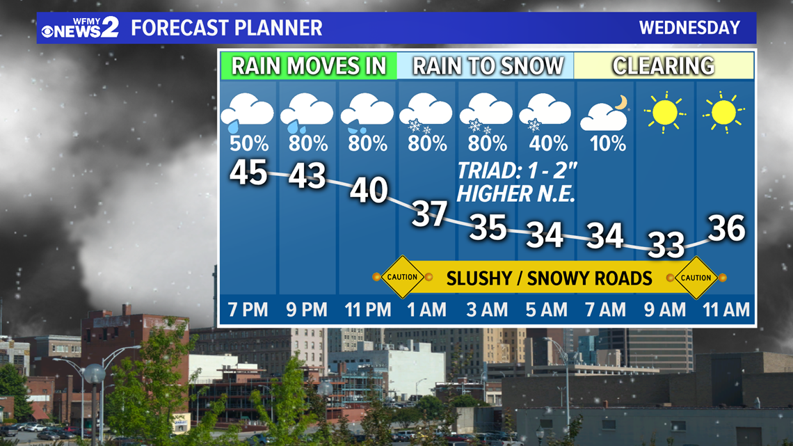
Midnight Thursday- 5 AM: Rain changes over to wet snow, mainly north of Asheboro, a few flakes could mix south of Asheboro, but mainly staying cold rain.


Thursday afternoon the sunshine will return but it will be cold with highs only near 40 and it will also be windy. With the wind, it could feel like it's freezing or below at times.
HOW MUCH?
For the Triad area, 1-2" is possible with locally higher amounts to the North and Northeast, where 2-4" are possible.
Further south of I-40 a Trace to 1" will be possible.
Back to the west, along the Foothills, only a Trace - 1" can be expected now with moisture, and cold air likely not arriving in time.
This is not a guaranteed snowfall, as things could change. We'll adjust as needed.
If these trends continue we'll of course adjust our forecast up as needed.


IMPACTS:
Slushy and snowy roads may be a problem Thursday morning making for a rough morning commute. Downed trees or power issues are not expected with this system as of now, but we'll continue to monitor the forecast.
WHAT TO DO:
It's always a good idea to make sure your electronics are charged up just in case you were to briefly lose power, but those impacts are not expected with this system currently.
As of now, it's best to pay attention to the forecast in case the chance for accumulating snow increases or heads upward over the next 24 hours. The WFMY Weather Team will be on top of it tracking it for you and keeping you updated on air and online.