GREENSBORO, N.C. — We're into the month of December and it's time to take a look at what the 2020-2021 winter may bring for the Piedmont-Triad. The WFMY News 2 Weather Team has been studying the weather patterns most likely to unfold over the next few months. Here's what they found after doing their research and applying their forecasting experience for our area.
IT'S A LA NIÑA YEAR (NOT EL NIÑO)
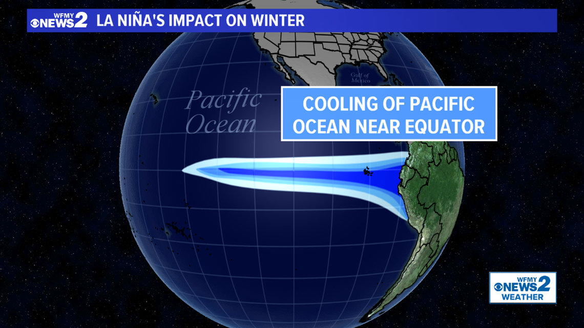
A lot of times during winter we talk about an El Niño weather pattern, but this year we're talking about the complete opposite, a La Niña pattern. What is it, and why do we care?
During a La Niña weather pattern, the water near the equator in the Pacific Ocean is much colder than normal which can have impacts on our weather all the way on the east coast of the U.S. We are in a moderate to strong La Niña right now.

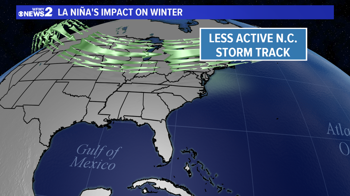
That colder water changes the intensity and location of the subtropical jet stream, which is our storm track that drives weather systems our way. During La Niña it lives farther to the north, meaning not as many storms track toward North Carolina. Simply put, we don't tend to get as many chances for rain and snow.
At the same time, the polar jet stream (which determines how far south Arctic air can roam) tends to be a bit farther to the north as well. This means we typically don't have as many outbreaks of bitterly cold air; although it can still happen on occasion.

Taking all this into account, in the Carolinas we tend to have drier than average weather during a La Niña winter. Temperatures tend to be near average, but can often be a tad warmer.
Using a climate signal like La Niña is just one aspect of forecasting weather during the winter months, but it can give us a guide.
WHAT ABOUT PAST LA NIÑA YEARS?
The past can be helpful in predicting the future. We narrowed down some other years with similar characteristics to this year. Specifically, we looked at other La Niña winters with special attention given to years that featured a moderate or strong La Niña similar to what we expect this year.
From that data, we can draw some conclusions on what the temperatures, precipitation, and snowfall were like. Let's start with precipitation.

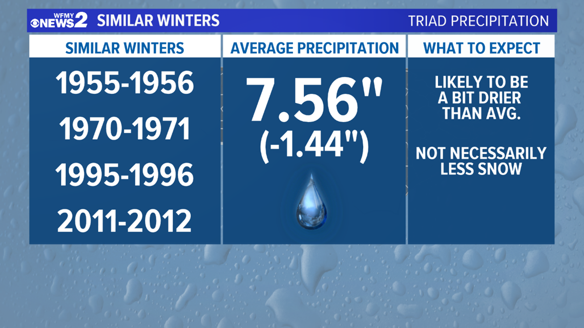
Precipitation during these similar winters tended to be lower than average. This was a fairly strong signal. This makes sense given the fact that the jet stream tends to be a bit farther north, causing storms to miss our area more often than hitting it. Based on this data, we can re-affirm the idea that a La Niña tends to be a drier one for North Carolina, including here in the Piedmont-Triad. Keep in mind, we're talking about overall precipitation here. This doesn't necessarily mean lower snowfall. More on that as we continue.


Temperatures in these similar winters tended to actually be a smidge below average. Not by much, just by about half a degree. That goes against the conventional wisdom that La Niña tends to be warmer for our area. Based on this data, it appears to us that near-normal temperatures are likely - although they could even be a bit above average taking into account how the climate has warmed in recent decades.
WHAT ABOUT SNOW?
Snow is always the number 1 question when it comes to winter forecasting, but also the hardest to answer for our area. You see, we don't get snow all that often in our climate, so sometimes the snow total for a whole winter is only based on one or two storms. From a statistical standpoint, past data only offers us so many data points to analyze.
For that reason, you can have a "snowy" winter during a warm year, or a cold year that doesn't have much snow, or a dry year that has a lot of snow, or a wet year that doesn't have much snow. So, our predictions are a guide, but certainly not gospel.
With all the caveats above, we of course looked at past data for snowfall given the weather pattern expected for our upcoming winter. Here's what we found.


Looking at those moderate to strong La Niña years, there was more snow than you may expect. Numbers were only slightly down when you took an average of similar winters. However, there were more below-average years and only a few above-average years.
Given this small sample size, it appears snowfall near or below average can be expected during a winter like this.
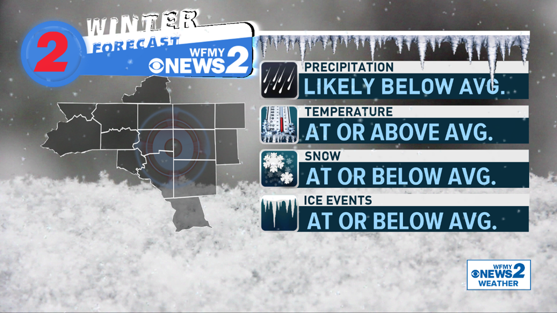
WFMY NEWS 2 WINTER FORECAST
We talked about La Niña, and looked at past winters with a similar setup. We also looked at other factors, including climate change, which have a big impact on how our next few months will play out. Here's what we expect.
- Below-average precipitation
- A drier winter than usual based on La Niña
- Temperatures near average, or slightly above
- Past winters indicate near average temps. However, climate change could nudge them slightly higher
- Snowfall at or below average
- Past winters indicate a drier La Niña winter doesn't necessarily mean less snowfall.
- Fewer snow/ice events than usual appear likely, but a "big storm" can happen in any year

THINGS TO KEEP IN MIND
It can get confusing when snow rumors start to fly in the South. We have some tips to keep your snow sanity and to make sure you're getting the best info and don't get fooled by the fake stuff.

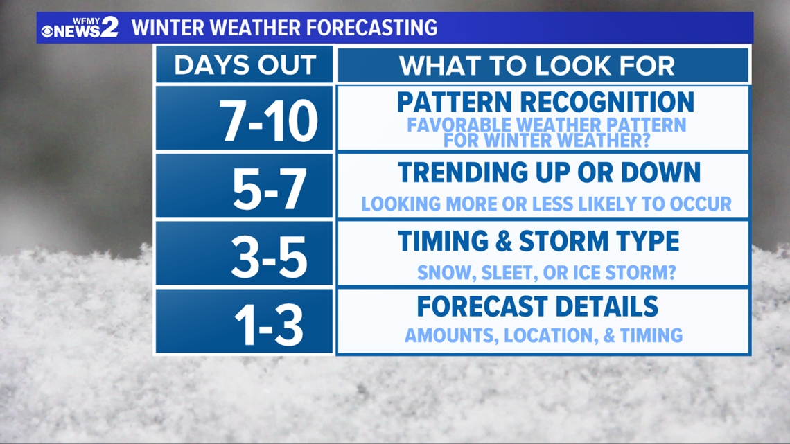
Winter weather forecasting in the south is a process. It's simply not possible to know if we're getting snow a week in advance. In fact, there are some rules of thumb to keep in mind.
- A week out, all we can really say is whether we're in a good weather pattern for winter weather. We'll look for a source of cold air and an active storm track. Can't get a storm without these factors.
- Within 5 days, we'll start to assess whether a storm is trending more likely or less likely
- Within 3 days, we can start to determine if we're looking at all snow, a mixed bag, mostly ice, or all rain.
- 1-3 days away, that's when we can finally start drawing accumulation maps and give you precise timing.
Keeping these timelines in mind will help you know if what you're seeing on social media. Better yet, check our app, our Facebook pages, and our newscasts for our expert opinions on the storm potential.

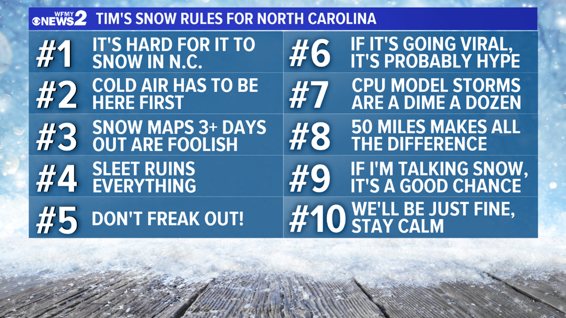
Keep "Tim's Snow Rules for NC" in mind. A lot of things have to go right for it to snow big here in North Carolina. Each and every year nowadays we start to see viral posts on social media about a big storm on the way. Don't fall for the hype. If it looks or sounds too good to be true, it probably is. Take a deep breath, and check our forecast.
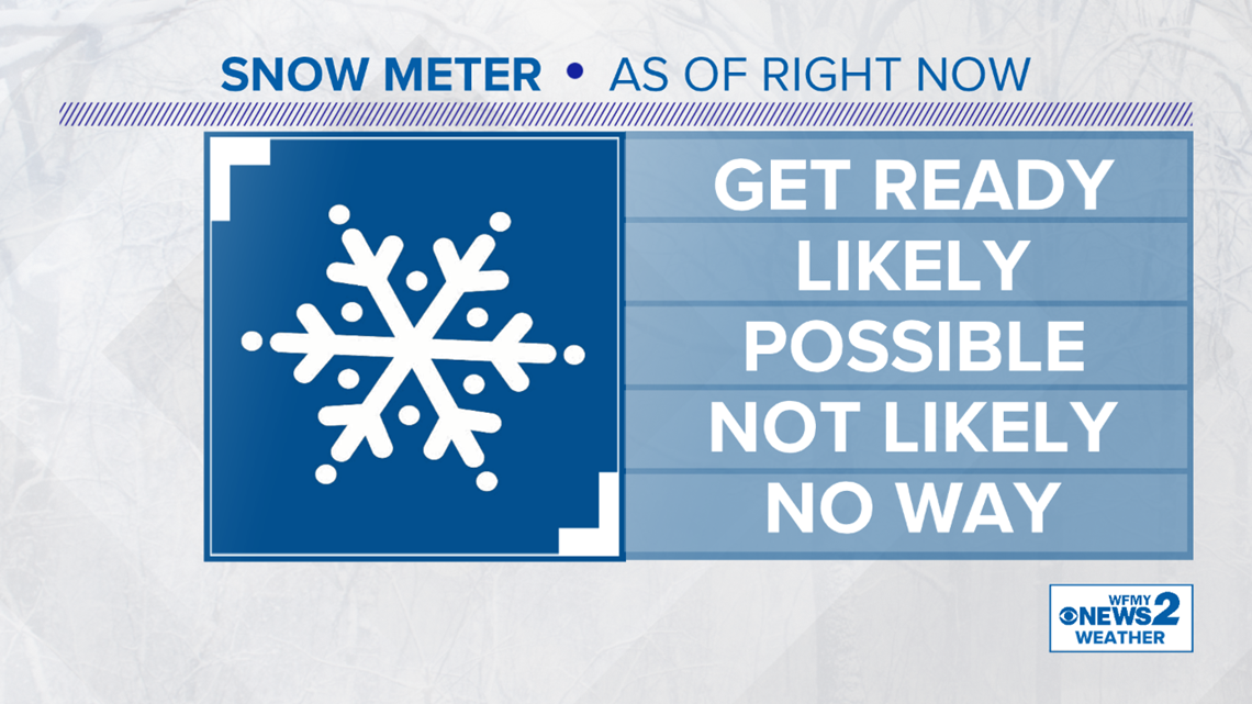
Finally, sometimes it's best to keep it simple. After we show you all the maps and break it down for you, we'll use our WFMY Snow Meter to give you an honest and simple idea of how likely a snow threat is. Whether it's "not likely", "possible", or "likely" can give you an idea of where our head is as we're forecasting the storms for you.